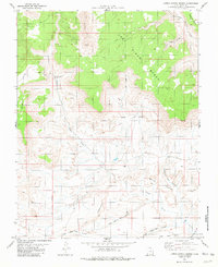
1981 Map of Lower Coyote Spring
USGS Topo · Published 1981About this map
Coyote Creek carves through the heart of this Kane County landscape, revealing a complex network of plateaus and erosion-carved canyons as they appeared in the early 1980s. The terrain is defined by massive formations such as Jack Riggs Bench and Brigham Plains, which drop away into deep incisions like Chyhoweth Canyon and Riggs Canyon. Near the southern extent of the survey, the Salt Lake Meridian provides a primary surveying reference point, cutting past the isolated settlement at Adair.
Find a feature on this map
23 named features on this map. Tap any name to fly to it.
Don’t see what you’re looking for? This feature index may not catch every label — zoom into the map to look around manually.
Map Details
Editions of this 1981 Lower Coyote Spring Map
This is the sole edition of this map. No revisions or reprints were ever made.
Other maps of this area

1886 · Escalante
USGS Topo · 1:250,000

1922 · Upper Last Chance
USGS Topo · 1:63,360

1953 · Nipple Butte
USGS Topo · 1:62,500

1954 · Paria NW
USGS Topo · 1:24,000
1954 · Paria SW
USGS Topo · 1:24,000

1954 · Paria
USGS Topo · 1:62,500

1955 · The Cockscob SW
USGS Topo · 1:24,000

1956 · Escalante
USGS Topo · 1:250,000

1960 · Escalante
USGS Topo · 1:250,000

1964 · Horse Flat
USGS Topo · 1:24,000