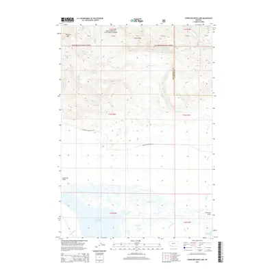
2014 Map of Lower Red Rock Lake
USGS Topo · Published 2014About this map
Lower Red Rock Lake and the marshy expanses of the Centennial Valley dominate this high-altitude landscape in the early 21st century. The map illustrates a complex drainage system where Odell Cr and Red Rock Creek feed into the lake, creating a network of wetlands and seasonal sloughs like Sparrow Slough. To the north, the terrain rises sharply into the Beaverhead National Forest, featuring landmarks such as Landon Ridge and Patchtop Mtn. The hydrology of the area is further defined by various named water sources, including Cayuse Spring and the W Fork Madison River. This geography supports a unique ecological corridor at the boundary of Beaverhead and Madison Counties, where Northside Centennial Rd provides the primary traverse through the valley floor, connecting the remote drainage basins of the Missouri River headwaters.
Find a feature on this map
22 named features on this map. Tap any name to fly to it.
Don’t see what you’re looking for? This feature index may not catch every label — zoom into the map to look around manually.
Map Details
Editions of this 2014 Lower Red Rock Lake Map
This is the sole edition of this map. No revisions or reprints were ever made.
Other maps of this area

1950 · Cliff Lake
USGS Topo · 1:62,500

1950 · Lower Red Rock Lake
USGS Topo · 1:62,500

1950 · Monument Ridge
USGS Topo · 1:62,500

1950 · Upper Red Rock Lake
USGS Topo · 1:62,500

1955 · Ashton
USGS Topo · 1:250,000

1958 · Ashton
USGS Topo · 1:250,000

1960 · Ashton
USGS Topo · 1:250,000
1988 · Eureka Basin
USGS Topo · 1:24,000
1988 · Freezeout Mountain
USGS Topo · 1:24,000
1988 · Lower Red Rock Lake
USGS Topo · 1:24,000