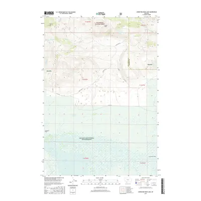
2017 Map of Lower Red Rock Lake
USGS Topo · Published 2017About this map
Centennial Valley dominates this landscape, serving as a vital high-altitude wetland corridor within the Red Rock Lakes National Wildlife Refuge. The map illustrates a complex hydrological system where Lower Red Rock Lake is fed by numerous descending waterways, including Odell Creek and Matsingale Cr. To the north, the terrain rises sharply toward Patchtop Mtn and the Landon Ridge, where the drainage shifts into the W Fork Madison River watershed. This area, managed partly by the Beaverhead National Forest, remains a critical conservation zone with very few improved roads, though Landon Ridge Rd and N Valley Rd provide essential access. The presence of features like Coyote Spring and Sparrow Slough highlights the intricate water distribution that sustains this remote Montana ecosystem.
Find a feature on this map
29 named features on this map. Tap any name to fly to it.
Don’t see what you’re looking for? This feature index may not catch every label — zoom into the map to look around manually.
Map Details
Editions of this 2017 Lower Red Rock Lake Map
This is the sole edition of this map. No revisions or reprints were ever made.
Other maps of this area

1950 · Cliff Lake
USGS Topo · 1:62,500

1950 · Lower Red Rock Lake
USGS Topo · 1:62,500

1950 · Monument Ridge
USGS Topo · 1:62,500

1950 · Upper Red Rock Lake
USGS Topo · 1:62,500

1955 · Ashton
USGS Topo · 1:250,000

1958 · Ashton
USGS Topo · 1:250,000

1960 · Ashton
USGS Topo · 1:250,000
1988 · Eureka Basin
USGS Topo · 1:24,000
1988 · Freezeout Mountain
USGS Topo · 1:24,000
1988 · Lower Red Rock Lake
USGS Topo · 1:24,000