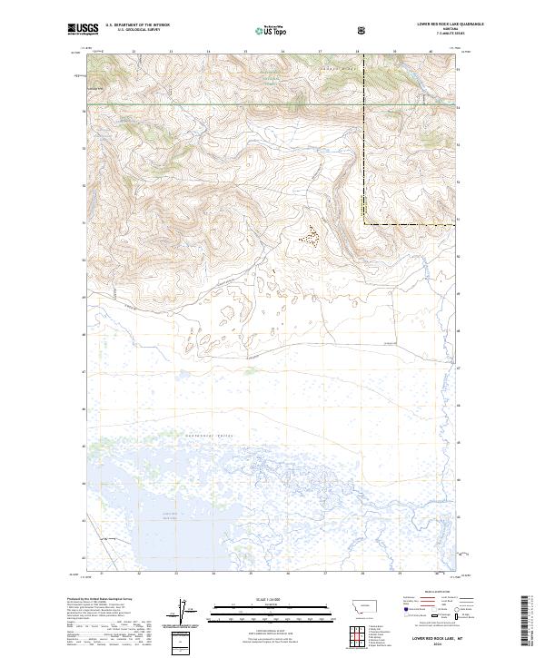
2024 Map of Lower Red Rock Lake
USGS Topo · Published 2024About this map
Centennial Valley dominates this high-altitude landscape where the complex wetlands of Lower Red Rock Lake transition into the slopes of Landon Ridge. This area is largely defined by conservation boundaries, including the Red Rock Lakes National Wildlife Refuge and the Red Rock Lakes Wilderness, which protect the intricate network of water features like Sparrow Slough and Nye Creek. To the north, the terrain rises toward Patchtop Mtn within the Beaverhead National Forest. The map illustrates a remote intersection of hydrology and topography, where the headwaters of the West Fork Madison River sit near the Continental Divide. Human presence is limited to scattered corridors like N Valley Rd and Landon Ridge Rd, reflecting a landscape managed primarily for wildlife and watershed integrity in the 21st century.
Find a feature on this map
33 named features on this map. Tap any name to fly to it.
Don’t see what you’re looking for? This feature index may not catch every label — zoom into the map to look around manually.
Map Details
Editions of this 2024 Lower Red Rock Lake Map
This is the sole edition of this map. No revisions or reprints were ever made.
Other maps of this area

1950 · Cliff Lake
USGS Topo · 1:62,500

1950 · Lower Red Rock Lake
USGS Topo · 1:62,500

1950 · Monument Ridge
USGS Topo · 1:62,500

1950 · Upper Red Rock Lake
USGS Topo · 1:62,500

1955 · Ashton
USGS Topo · 1:250,000

1958 · Ashton
USGS Topo · 1:250,000

1960 · Ashton
USGS Topo · 1:250,000
1988 · Eureka Basin
USGS Topo · 1:24,000
1988 · Freezeout Mountain
USGS Topo · 1:24,000
1988 · Lower Red Rock Lake
USGS Topo · 1:24,000