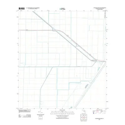
2012 Map of Loxahatchee NW
USGS Topo · Published 2012About this map
The Twentymile Bend settlement serves as a focal point in this portion of the Florida Everglades, where a complex network of agricultural and drainage infrastructure defines the landscape. The geography is dictated by the massive West Palm Beach Canal and the L-7 Canal, which form the primary water management arteries for the region. These engineered waterways are accompanied by secondary features like the Ocean Canal, illustrating the sophisticated irrigation and flood control systems vital to Palm Beach County's interior. A grid of local roads, including E Canal St S, supports the local economy and land use pattern in this specialized environment, offering researchers a detailed view of the area's twentieth-century hydrological and transport development.
Find a feature on this map
5 named features on this map. Tap any name to fly to it.
Don’t see what you’re looking for? This feature index may not catch every label — zoom into the map to look around manually.
Map Details
Editions of this 2012 Loxahatchee NW Map
This is the sole edition of this map. No revisions or reprints were ever made.
Other maps of this area

1956 · West Palm Beach
USGS Topo · 1:250,000

1957 · West Palm Beach
USGS Topo · 1:250,000

1958 · West Palm Beach
USGS Topo · 1:250,000

1970 · West Palm Beach 2 SW
USGS Topo · 1:24,000
1970 · Loxahatchee SE
USGS Topo · 1:24,000

1970 · Loxahatchee NW
USGS Topo · 1:24,000

1970 · Loxahatchee SW
USGS Topo · 1:24,000

1970 · Shawano
USGS Topo · 1:24,000

1970 · Bryant
USGS Topo · 1:24,000

1970 · Sixmile Bend
USGS Topo · 1:24,000