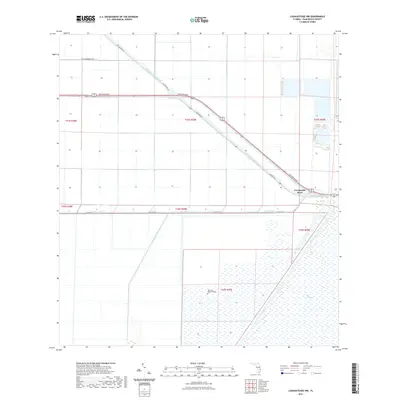
2021 Map of Loxahatchee NW
USGS Topo · Published 2021About this map
Twentymile Bend serves as the central junction where the West Palm Beach Canal meets the drainage infrastructure of the northern Florida interior. This 2021 survey illustrates a landscape defined by the engineered movement of water, where the grid of the Public Land Survey System intersects with the diagonal routes of Southern Blvd and Connors Hwy. The southern portion of the map transitions into the expansive wetlands of The Everglades, bordered by the L-7 Canal. Human activity is primarily oriented around these major transportation corridors and water management features, including the Riverside Memorial Park and local routes like Old Connors Rd and New Vandergrift Rd. The map provides a contemporary look at how the region's agricultural and transit needs are balanced with the natural environment of the marshlands.
Find a feature on this map
17 named features on this map. Tap any name to fly to it.
Don’t see what you’re looking for? This feature index may not catch every label — zoom into the map to look around manually.
Map Details
Editions of this 2021 Loxahatchee NW Map
This is the sole edition of this map. No revisions or reprints were ever made.
Other maps of this area

1956 · West Palm Beach
USGS Topo · 1:250,000

1957 · West Palm Beach
USGS Topo · 1:250,000

1958 · West Palm Beach
USGS Topo · 1:250,000

1970 · West Palm Beach 2 SW
USGS Topo · 1:24,000
1970 · Loxahatchee SE
USGS Topo · 1:24,000

1970 · Loxahatchee NW
USGS Topo · 1:24,000

1970 · Loxahatchee SW
USGS Topo · 1:24,000

1970 · Shawano
USGS Topo · 1:24,000

1970 · Bryant
USGS Topo · 1:24,000

1970 · Sixmile Bend
USGS Topo · 1:24,000