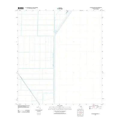
2012 Map of Loxahatchee SW
USGS Topo · Published 2012About this map
Hillsboro Canal cuts a distinct diagonal through this portion of Palm Beach County, illustrating the massive hydrological engineering required to manage water in the Florida Everglades. This 2012 survey by the U.S. Geological Survey reveals a landscape dominated by the geometry of large-scale agriculture and water management infrastructure. The L-7 Canal runs vertically through the center of the sheet, acting as a boundary for the rectangular grids of the surrounding fields. While the area lacks traditional towns or settlements, the presence of Brown's Farm Rd following the path of the canal highlights the essential connection between transportation routes and water management in this highly controlled environment.
Find a feature on this map
3 named features on this map. Tap any name to fly to it.
Don’t see what you’re looking for? This feature index may not catch every label — zoom into the map to look around manually.
Map Details
Editions of this 2012 Loxahatchee SW Map
This is the sole edition of this map. No revisions or reprints were ever made.
Other maps of this area

1956 · West Palm Beach
USGS Topo · 1:250,000

1957 · West Palm Beach
USGS Topo · 1:250,000

1958 · West Palm Beach
USGS Topo · 1:250,000
1970 · Loxahatchee SE
USGS Topo · 1:24,000

1970 · Loxahatchee NW
USGS Topo · 1:24,000

1970 · Loxahatchee SW
USGS Topo · 1:24,000

1970 · Shawano
USGS Topo · 1:24,000

1970 · Sixmile Bend
USGS Topo · 1:24,000
1971 · Loxahatchee
USGS Topo · 1:24,000
1973 · Fort Lauderdale 2 NE
USGS Topo · 1:24,000