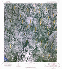
1973 Map of Fort Lauderdale 2 NE
USGS Topo · Published 1976About this map
Loxahatchee National Wildlife Refuge dominates this orthophotomap, showing the intricate textured surface of the Florida Everglades as it appeared in the early 1970s. The region is defined by Conservation Area No 1, where water is noted to be impounded periodically, creating a landscape of shallow wetlands and vegetation islands. Evidence of human presence and managed water systems are found at Bobs Camp and along the L-39 Canal. This 1971 aerial perspective captures the seasonal hydrology of the region, including features like Bobs Lake and Bend 2, providing a detailed look at the wetland patterns before later development or restoration efforts changed the local drainage and footprint of these conservation lands.
Find a feature on this map
7 named features on this map. Tap any name to fly to it.
Don’t see what you’re looking for? This feature index may not catch every label — zoom into the map to look around manually.
Map Details
Editions of this 1973 Fort Lauderdale 2 NE Map
2 editions found
Other maps of this area

1945 · Greenacres City
USGS Topo · 1:24,000

1946 · West Dixie Bend
USGS Topo · 1:24,000

1947 · Delmar Farms
USGS Topo · 1:24,000

1949 · West Dixie Bend
USGS Topo · 1:24,000

1949 · Delmar Farms
USGS Topo · 1:24,000

1950 · Greenacres City
USGS Topo · 1:24,000

1956 · West Palm Beach
USGS Topo · 1:250,000

1957 · West Palm Beach
USGS Topo · 1:250,000

1958 · West Palm Beach
USGS Topo · 1:250,000
1962 · West Dixie Bend
USGS Topo · 1:24,000