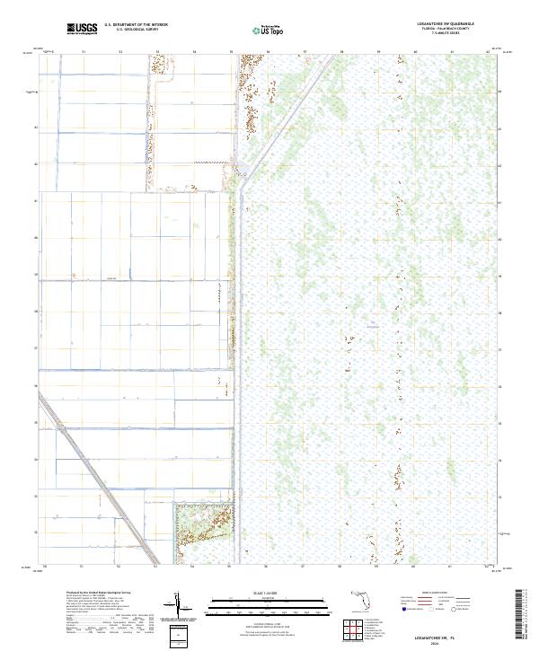
2024 Map of Loxahatchee SW
USGS Topo · Published 2024About this map
Arthur R Marshall Loxahatchee National Wildlife Refuge dominates the eastern landscape of this Palm Beach County quadrangle, representing a vast preserved section of The Everglades. The map illustrates a sharp divide between conservation lands and the agricultural infrastructure to the west. This western portion is defined by a rigid grid of drainage and irrigation canals, including the prominent north-south L-7 Canal and the diagonal Hillsboro Canal. These waterways were essential to the development of the region's agricultural economy, supported by local transit routes like Dairy Rd and Co Hwy 827. The contrast between the open wetland ecosystems and the highly engineered water management systems captures the modern environmental character of southern Florida.
Find a feature on this map
9 named features on this map. Tap any name to fly to it.
Don’t see what you’re looking for? This feature index may not catch every label — zoom into the map to look around manually.
Map Details
Editions of this 2024 Loxahatchee SW Map
This is the sole edition of this map. No revisions or reprints were ever made.
Other maps of this area

1956 · West Palm Beach
USGS Topo · 1:250,000

1957 · West Palm Beach
USGS Topo · 1:250,000

1958 · West Palm Beach
USGS Topo · 1:250,000
1970 · Loxahatchee SE
USGS Topo · 1:24,000

1970 · Loxahatchee NW
USGS Topo · 1:24,000

1970 · Loxahatchee SW
USGS Topo · 1:24,000

1970 · Shawano
USGS Topo · 1:24,000

1970 · Sixmile Bend
USGS Topo · 1:24,000
1971 · Loxahatchee
USGS Topo · 1:24,000
1973 · Fort Lauderdale 2 NE
USGS Topo · 1:24,000