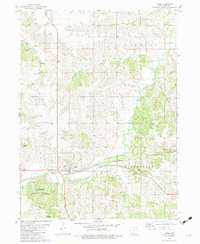
1982 Map of Lucas
USGS Topo · Published 1983About this map
The town of Lucas sits at a critical rail intersection in southern Iowa, where the Burlington Northern railroad tracks parallel the winding course of White Breast Creek. This 1982 survey illustrates a landscape defined by its rolling topography and numerous small stream valleys, including Indian Creek, Otter Creek, and Barker Creek. The rural character of Lucas County is evident in the preservation of several family and community burial grounds scattered across the terrain, such as Rose Hill Cem, Fox Hill Cem, and Clore Cem. To the southwest, the wooded expanses of Stephens State Forest provide a contrast to the surrounding agricultural fields, complete with a designated Campground and Picnic Area. The map captures the quiet persistence of small settlements like Norwood and the intricate network of local drainage that has shaped the region's development.
Find a feature on this map
26 named features on this map. Tap any name to fly to it.
Don’t see what you’re looking for? This feature index may not catch every label — zoom into the map to look around manually.
Map Details
Editions of this 1982 Lucas Map
This is the sole edition of this map. No revisions or reprints were ever made.
Other maps of this area

1918 · Chariton
USGS Topo · 1:62,500

1934 · Humeston
USGS Topo · 1:48,000

1937 · Corydon
USGS Topo · 1:62,500

1950 · New Virginia
USGS Topo · 1:62,500

1952 · New Virginia
USGS Topo · 1:62,500

1954 · Centerville
USGS Topo · 1:250,000

1954 · Des Moines
USGS Topo · 1:250,000

1956 · Des Moines
USGS Topo · 1:250,000

1957 · Des Moines
USGS Topo · 1:250,000

1957 · Centerville
USGS Topo · 1:250,000