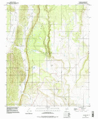
1994 Map of Lucero
USGS Topo · Published 1998About this map
Lucero and several family-named settlements dot the western slopes of La Mesa in this mid-1990s depiction of Mora County. The landscape is defined by the deep incisions of Guadalupita Canyon and Silva Canyon, where the drainage of Coyote Creek follows the base of El Cerro Colorado. Evidence of the area's spiritual and community history is anchored by the El Convento (Ruins) and the La Morada Cem near the southern edge of the map. Smaller pockets of habitation like Los Cocos, Los Cisneros, and Los Medinas suggest a traditional land use pattern tied to the water sources of La Jara Creek and Amador Lake. Several marked Prospect locations and Jeep Trails indicate historical mineral exploration across the high plateau and canyon floors, reflecting a rural economy shaped by both rugged topography and the persistent flow of high-elevation streams.
Find a feature on this map
20 named features on this map. Tap any name to fly to it.
Don’t see what you’re looking for? This feature index may not catch every label — zoom into the map to look around manually.
Map Details
Editions of this 1994 Lucero Map
This is the sole edition of this map. No revisions or reprints were ever made.
Other maps of this area

1889 · Las Vegas
USGS Topo · 1:125,000

1891 · Las Vegas
USGS Topo · 1:125,000

1893 · Las Vegas
USGS Topo · 1:125,000

1954 · Santa Fe
USGS Topo · 1:250,000

1954 · Raton
USGS Topo · 1:250,000

1958 · Raton
USGS Topo · 1:250,000

1958 · Santa Fe
USGS Topo · 1:250,000

1963 · Fort Union
USGS Topo · 1:24,000

1963 · Rainsville
USGS Topo · 1:24,000

1965 · Chacon
USGS Topo · 1:24,000