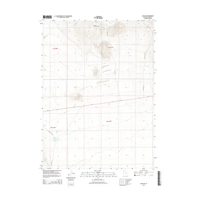
2014 Map of Lucin NE
USGS Topo · Published 2014About this map
The Grouse Creek Mountains anchor the northern landscape of this Box Elder County region, where the high-altitude terrain gives way to the arid flats of the Great Basin. Water sources are the critical defining feature of this expanse, with Owl Spring, East Rabbit Spring, and Rabbit Spring providing rare moisture in a desert environment. The presence of the Rabbit Spring Reservoir suggests a managed effort to capture and store this vital resource for livestock or local use. Transportation through this remote section of Utah is defined by utilitarian paths and historic routes, including the paved stretch of Ut-30 and specialized tracks like Lucin Airport Rd and Rabbit Springs Loop. The map also traces the Emigrant Pass Rd, a name that evokes the historical transit of 19th-century travelers through these rugged mountain gaps.
Find a feature on this map
16 named features on this map. Tap any name to fly to it.
Don’t see what you’re looking for? This feature index may not catch every label — zoom into the map to look around manually.
Map Details
Editions of this 2014 Lucin NE Map
This is the sole edition of this map. No revisions or reprints were ever made.
Other maps of this area

1954 · Brigham City
USGS Topo · 1:250,000

1958 · Brigham City
USGS Topo · 1:250,000

1962 · Brigham City
USGS Topo · 1:250,000
1967 · Pigeon Mountain
USGS Topo · 1:24,000
1967 · Lucin
USGS Topo · 1:24,000
1967 · Lucin NW
USGS Topo · 1:24,000
1967 · Lucin NE
USGS Topo · 1:24,000
1971 · Emigrant Pass
USGS Topo · 1:24,000
1971 · Toms Cabin Spring
USGS Topo · 1:24,000
1971 · Rocky Pass Peak
USGS Topo · 1:24,000