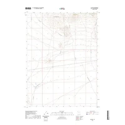
2023 Map of Lucin NE
USGS Topo · Published 2023About this map
The Grouse Creek Mountains and Bovine Mountains define the high desert landscape of this Box Elder County quadrangle. Water sources are critical landmarks in this arid region, clustered primarily at the foot of the slopes. Local geography is centered around the Rabbit Spring Reservoir, fed by Rabbit Spring and East Rabbit Spring, providing a vital oasis for grazing or transit in the West Desert. A network of primitive and improved routes, such as Emigrant Trail Rd and Mud Basin Rd, suggests a landscape used primarily for ranching and access to high-country basins. The presence of the Lucin Airport Rd and Pigeon Mountain Loop highlights how modern transit and local loops have overlaid older tracks through these remote mountain passes.
Find a feature on this map
15 named features on this map. Tap any name to fly to it.
Don’t see what you’re looking for? This feature index may not catch every label — zoom into the map to look around manually.
Map Details
Editions of this 2023 Lucin NE Map
This is the sole edition of this map. No revisions or reprints were ever made.
Other maps of this area

1954 · Brigham City
USGS Topo · 1:250,000

1958 · Brigham City
USGS Topo · 1:250,000

1962 · Brigham City
USGS Topo · 1:250,000

1967 · Pigeon Mountain
USGS Topo · 1:24,000

1967 · Lucin
USGS Topo · 1:24,000
1967 · Lucin NW
USGS Topo · 1:24,000

1967 · Lucin NE
USGS Topo · 1:24,000

1971 · Emigrant Pass
USGS Topo · 1:24,000
1971 · Toms Cabin Spring
USGS Topo · 1:24,000
1971 · Rocky Pass Peak
USGS Topo · 1:24,000