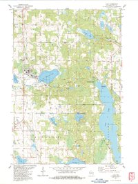
1983 Map of Luck
USGS Topo · Published 1983About this map
Luck and Milltown anchor this Polk County landscape during the early 1980s, situated along the corridor of the Soo Line railroad. The region is defined by a dense concentration of glacial lakes, with the expansive Bone Lake stretching along the eastern boundary and Big Butternut Lake serving as a central focal point for the community of Luck. Evidence of local life is visible through features like the Substation Trailer Park and the Chippewa Trail winding through the center of the sheet.
Find a feature on this map
44 named features on this map. Tap any name to fly to it.
Don’t see what you’re looking for? This feature index may not catch every label — zoom into the map to look around manually.
Map Details
Editions of this 1983 Luck Map
This is the sole edition of this map. No revisions or reprints were ever made.
Other maps of this area

1900 · St Croix Dalles
USGS Topo · 1:62,500

1901 · St Croix Dalles
USGS Topo · 1:62,500

1950 · Balsam Lake
USGS Topo · 1:62,500

1951 · Milltown
USGS Topo · 1:48,000

1951 · Frederic
USGS Topo · 1:48,000

1953 · Stillwater
USGS Topo · 1:250,000

1955 · St. Croix Dalles
USGS Topo · 1:62,500

1955 · Frederic
USGS Topo · 1:62,500

1955 · Milltown
USGS Topo · 1:62,500

1955 · Stillwater
USGS Topo · 1:250,000