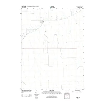
2010 Map of Ludell
USGS Topo · Published 2010About this map
Ludell serves as the central point of this High Plains landscape in Rawlins County, situated along the winding course of Beaver Creek. The settlement pattern is defined by a rigid grid of rural routes, including Co RD 439 and Co RD O, which segment the agricultural terrain. Genealogy researchers will find significant value in the location of two distinct burial sites: Immanuel Cemetery to the north and Ludell Cemetery situated to the south of the main cluster of buildings. The topography is characterized by the drainage patterns of the creek and its unnamed tributaries, which create the only breaks in the otherwise geometric layout of the county's road system. This 2010 survey provides a clear look at the contemporary footprint of this small Kansas community, preserving the location of its essential civic and commemorative spaces.
Find a feature on this map
6 named features on this map. Tap any name to fly to it.
Don’t see what you’re looking for? This feature index may not catch every label — zoom into the map to look around manually.
Map Details
Editions of this 2010 Ludell Map
This is the sole edition of this map. No revisions or reprints were ever made.
Other maps of this area

1951 · Herndon
USGS Topo · 1:62,500

1951 · Achilles
USGS Topo · 1:62,500

1951 · Atwood
USGS Topo · 1:62,500

1951 · Chardon
USGS Topo · 1:62,500

1954 · Goodland
USGS Topo · 1:250,000

1956 · Goodland
USGS Topo · 1:250,000

1957 · Goodland
USGS Topo · 1:250,000

1965 · Achilles
USGS Topo · 1:24,000
1978 · Atwood
USGS Topo · 1:24,000
1978 · Herndon
USGS Topo · 1:24,000