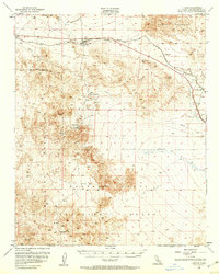
1955 Map of Ludlow
USGS Topo · Published 1960About this map
The high desert settlement of Ludlow serves as the central hub of this Mojave landscape, situated along the Atchison Topeka and Santa Fe railroad. The map documents an era of industrial transition, showing the infrastructure of the Old Railroad Grade and numerous mining sites that shaped local history. To the south, the Bagdad Chase Mine and the settlement of Stedman indicate the importance of mineral extraction in the Bullion Mountains, while smaller operations like the Old Pete Mine and Dictator No 1 Mine are scattered across the surrounding peaks. This 1955 survey also clearly delineates the massive Marine Corps Training Center and a Naval Reservation, reflecting the region's mid-century military significance. Smaller named locales such as Ragtown, Klondike, and Argos trace the sparse but vital corridor of human activity through the arid terrain of the Bristol Mountains.
Find a feature on this map
29 named features on this map. Tap any name to fly to it.
Don’t see what you’re looking for? This feature index may not catch every label — zoom into the map to look around manually.
Map Details
Editions of this 1955 Ludlow Map
2 editions found

Other maps of this area

1942 · Amboy
USGS Topo · 1:250,000

1943 · Amboy
USGS Topo · 1:250,000

1953 · San Bernardino
USGS Topo · 1:250,000

1954 · Needles
USGS Topo · 1:250,000

1954 · Hidalgo Mtn
USGS Topo · 1:24,000

1954 · Bagdad SW
USGS Topo · 1:24,000

1954 · Ludlow SE
USGS Topo · 1:24,000

1955 · Deadman Lake NW
USGS Topo · 1:24,000

1955 · Ludlow
USGS Topo · 1:24,000

1955 · Lavic SE
USGS Topo · 1:24,000