
1949 Map of Lufkin
USGS Topo · Published 1961About this map
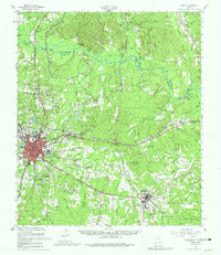
The Angelina River and Neches River frame a landscape of deep piney woods and burgeoning industry in East Texas. In the mid-century, Lufkin stands as a primary hub of development, flanked by established smaller communities like Keltys, Herty, and the site of the former county seat at Homer. The map records a complex local infrastructure of timber and transport, including the Forestry Experiment Station and the Southern Pacific railroad line.
Find a feature on this map
82 named features on this map. Tap any name to fly to it.
Don’t see what you’re looking for? This feature index may not catch every label — zoom into the map to look around manually.
Map Details
Editions of this 1949 Lufkin Map
2 editions found
Other maps of this area

1931 · Zavalla
USGS Topo · 1:62,500

1932 · Manning
USGS Topo · 1:62,500

1949 · Platt
USGS Topo · 1:24,000

1949 · Clawson
USGS Topo · 1:24,000

1949 · Lufkin
USGS Topo · 1:24,000

1949 · Huntington
USGS Topo · 1:24,000

1949 · Keltys
USGS Topo · 1:24,000

1950 · Platt
USGS Topo · 1:24,000

1950 · Keltys
USGS Topo · 1:24,000

1950 · Lufkin
USGS Topo · 1:24,000