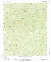
1964 Map of Luftee Knob
USGS Topo · Published 1987About this map
Great Smoky Mountains National Park dominates this high-altitude landscape along the border of North Carolina and Tennessee in the mid-1960s. The topography is defined by the massive Balsam Mountain range, where peaks like Luftee Knob and Mount Yonaguska reach into the clouds. The survey captures a network of footpaths and historical transit routes, most notably the Appalachian Trail as it traverses ridges from Camel Hump Knob toward Cosby Knob.
Find a feature on this map
114 named features on this map. Tap any name to fly to it.
Don’t see what you’re looking for? This feature index may not catch every label — zoom into the map to look around manually.
Map Details
Editions of this 1964 Luftee Knob Map
4 editions found
Other maps of this area

1893 · Mt Guyot
USGS Topo · 1:125,000

1912 · Mt Guyot
USGS Topo · 1:125,000

1935 · Newport
USGS Topo · 1:48,000

1935 · Hartford
USGS Topo · 1:24,000

1935 · English Mountain
USGS Topo · 1:48,000

1935 · Dellwood
USGS Topo · 1:24,000

1935 · Jones Cove
USGS Topo · 1:24,000

1936 · Bunches Bald
USGS Topo · 1:24,000
1936 · Cove Creek Gap
USGS Topo · 1:24,000
1936 · Waterville
USGS Topo · 1:24,000