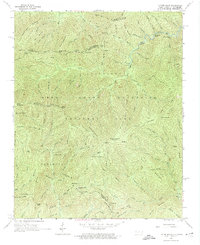
1964 Map of Luftee Knob
USGS Topo · Published 1987About this map
Balsam Mountain forms the high spine of this high-elevation wilderness along the border of Cocke and Haywood counties. Centered on the high peaks of the Great Smoky Mountains National Park, the map captures the region in the mid-1960s, prior to modern environmental shifts but long after the initial establishment of the park. The geography is defined by deep drainages and sharp ridges, where water features like Mouse Creek Falls and the headwaters of Big Creek dominate the lower elevations. The survey traces the winding path of the Appalachian Trail as it crosses Cosby Knob and Inadu Knob, passing near Brakeshoe Spring. This area represents a high-mountain landscape preserved from industrial development, where named heights like Luftee Knob and Mount Sterling serve as the primary landmarks for hikers and early conservationists.
Find a feature on this map
90 named features on this map. Tap any name to fly to it.
Don’t see what you’re looking for? This feature index may not catch every label — zoom into the map to look around manually.
Map Details
Editions of this 1964 Luftee Knob Map
4 editions found
Other maps of this area

1893 · Mt Guyot
USGS Topo · 1:125,000

1912 · Mt Guyot
USGS Topo · 1:125,000

1935 · Newport
USGS Topo · 1:48,000

1935 · Hartford
USGS Topo · 1:24,000

1935 · English Mountain
USGS Topo · 1:48,000

1935 · Dellwood
USGS Topo · 1:24,000

1935 · Jones Cove
USGS Topo · 1:24,000

1936 · Bunches Bald
USGS Topo · 1:24,000
1936 · Cove Creek Gap
USGS Topo · 1:24,000
1936 · Waterville
USGS Topo · 1:24,000