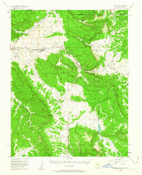
1955 Map of Lumberton
USGS Topo · Published 1963About this map
The Jicarilla Apache Indian Reservation dominates this mid-century landscape where the Denver and Rio Grande Western railroad threads through the canyons of northern New Mexico. Settlement patterns follow the rail corridor and the course of Amargo Creek, connecting the mountain towns of Lumberton, Dulce, and Monero. This area reflects a mid-1950s economy rooted in extraction and ranching, evidenced by the Carano Bros Mine and Lany Mine alongside established holdings like Rancho Diamante and Abeyta Ranch. The high-altitude terrain is defined by the Continental Divide and prominent landmarks like Archuleta Mesa, with water resources such as Horse Lake and the Navajo River providing essential lifelines in the high desert and mountain environment near the Colorado border.
Find a feature on this map
47 named features on this map. Tap any name to fly to it.
Don’t see what you’re looking for? This feature index may not catch every label — zoom into the map to look around manually.
Map Details
Editions of this 1955 Lumberton Map
4 editions found

Other maps of this area

1889 · Largo
USGS Topo · 1:250,000

1895 · Largo
USGS Topo · 1:250,000

1913 · Summitville
USGS Topo · 1:125,000

1915 · Summitville
USGS Topo · 1:125,000

1924 · Pagosa Springs
USGS Topo · 1:125,000

1927 · Pagosa Springs
USGS Topo · 1:125,000

1945 · Durango
USGS Topo · 1:250,000

1953 · Durango
USGS Topo · 1:250,000

1954 · Durango
USGS Topo · 1:250,000

1954 · Aztec
USGS Topo · 1:250,000