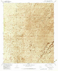
1982 Map of Lumley Lake NE
USGS Topo · Published 1982About this map
White Sands Missile Range dominates this high-desert landscape on the border of Sierra and Otero Counties, as documented in this 1982 orthophotomap. The terrain is characterized by sparse water sources and specialized land use, where man-made infrastructure like Crossroad Tank and Big Tank supported ranching or early settlement in a region later transition to military testing. The Denver Site appears in the northern reaches, while the southeastern corner is marked by seasonal water features like Turner Lake and the drainage of Three Rivers.
Find a feature on this map
9 named features on this map. Tap any name to fly to it.
Don’t see what you’re looking for? This feature index may not catch every label — zoom into the map to look around manually.
Map Details
Editions of this 1982 Lumley Lake NE Map
2 editions found
Other maps of this area

1916 · Tularosa
USGS Topo · 1:125,000

1947 · Three Rivers
USGS Topo · 1:62,500

1947 · Capitol Peak
USGS Topo · 1:62,500

1948 · Lumley Lake
USGS Topo · 1:62,500

1948 · Tularosa
USGS Topo · 1:62,500

1954 · Tularosa
USGS Topo · 1:250,000

1958 · Tularosa
USGS Topo · 1:250,000

1981 · Tularosa
USGS Topo · 1:100,000
1981 · Three Rivers SW
USGS Topo · 1:24,000
1981 · Sheep Mountain
USGS Topo · 1:24,000