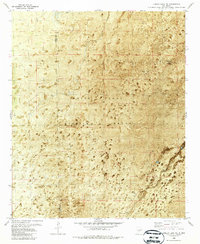
1982 Map of Lumley Lake NE
USGS Topo · Published 1987About this map
White Sands Missile Range dominates this orthophotomap of the arid Tularosa Basin, where the stark desert landscape is captured through aerial photography from the early 1970s. The map reveals a land dedicated to military and archaeological interest, marked by the Denver Site in the north and the N E 50 Site further south. This specialized 1980s edition uses an orthophotomosaic base to show the distribution of brush and alkaline flats across the Sierra Co Otero Co boundary. Water sources are vital but sparse in this environment, represented by infrastructure like Crossroad Tank, Turner Lake, and Big Tank. The presence of a Gravel Pit and scattered wells such as Turner Well point to the logistical requirements of maintaining operations in this restricted military zone.
Find a feature on this map
10 named features on this map. Tap any name to fly to it.
Don’t see what you’re looking for? This feature index may not catch every label — zoom into the map to look around manually.
Map Details
Editions of this 1982 Lumley Lake NE Map
2 editions found
Other maps of this area

1916 · Tularosa
USGS Topo · 1:125,000

1947 · Three Rivers
USGS Topo · 1:62,500

1947 · Capitol Peak
USGS Topo · 1:62,500

1948 · Lumley Lake
USGS Topo · 1:62,500

1948 · Tularosa
USGS Topo · 1:62,500

1954 · Tularosa
USGS Topo · 1:250,000

1958 · Tularosa
USGS Topo · 1:250,000

1981 · Tularosa
USGS Topo · 1:100,000
1981 · Three Rivers SW
USGS Topo · 1:24,000
1981 · Sheep Mountain
USGS Topo · 1:24,000