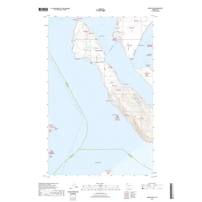
2020 Map of Lummi Island
USGS Topo · Published 2020About this map
Lummi Island and its surrounding archipelago define this maritime landscape in the Strait of Georgia. Residential development is concentrated along the northern and eastern shores, particularly at West Beach and Hermosa Beach, while the interior remains defined by topographic extremes such as Richards Mtn and the steep elevation of Lummi Peak. The presence of the Island Cem and a network of local roads like Legoe Bay Rd and N Nugent Rd reflect a long-established island community. Coastal geography is prominently detailed, showing the seasonal shifts and tidal connections at The Portage and Portage Channel which separate the main island from Portage Island. In the south, the terrain becomes increasingly complex with features like Devils Slide and Bakers Reef, illustrating the intersection of residential life and the geological character of the San Juan Islands.
Find a feature on this map
74 named features on this map. Tap any name to fly to it.
Don’t see what you’re looking for? This feature index may not catch every label — zoom into the map to look around manually.
Map Details
Editions of this 2020 Lummi Island Map
This is the sole edition of this map. No revisions or reprints were ever made.
Other maps of this area

1907 · Blaine
USGS Topo · 1:62,500

1943 · Orcas Island
USGS Topo · 1:62,500

1943 · Anacortes
USGS Topo · 1:62,500

1951 · Anacortes
USGS Topo · 1:62,500

1952 · Ferndale
USGS Topo · 1:24,000

1952 · Lummi Bay
USGS Topo · 1:24,000

1952 · Blaine
USGS Topo · 1:62,500

1957 · Orcas Island
USGS Topo · 1:62,500

1957 · Victoria
USGS Topo · 1:250,000

1973 · Cypress Island
USGS Topo · 1:24,000