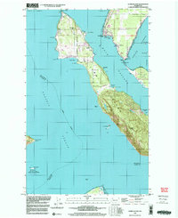
1998 Map of Lummi Island
USGS Topo · Published 2003About this map
Lummi Island sits at the convergence of the Strait of Georgia, Hale Passage, and Rosario Strait, serving as a central point in this coastal Washington geography. This 1990s survey illustrates a landscape of maritime connectivity and protected natural spaces, including the Lummi Indian Reservation and the San Juan Islands National Wildlife Refuge. The island's topography is anchored by Lummi Peak and Richards Mtn, while the shoreline is dotted with local landmarks like Loganita Lodge, The Willows, and the Grange Hall. Cultural details such as a Cem near Legoe Bay, a landing strip, and the Lummi Marine Park reflect the community's established infrastructure. To the south, Sinclair Island and Peapod Rocks mark the transition into the San Juan wilderness area, highlighting the balance between residential settlement and conservation.
Find a feature on this map
52 named features on this map. Tap any name to fly to it.
Don’t see what you’re looking for? This feature index may not catch every label — zoom into the map to look around manually.
Map Details
Editions of this 1998 Lummi Island Map
This is the sole edition of this map. No revisions or reprints were ever made.
Other maps of this area

1907 · Blaine
USGS Topo · 1:62,500

1943 · Orcas Island
USGS Topo · 1:62,500

1943 · Anacortes
USGS Topo · 1:62,500

1951 · Anacortes
USGS Topo · 1:62,500

1952 · Ferndale
USGS Topo · 1:24,000

1952 · Lummi Bay
USGS Topo · 1:24,000

1952 · Blaine
USGS Topo · 1:62,500

1957 · Orcas Island
USGS Topo · 1:62,500

1957 · Victoria
USGS Topo · 1:250,000

1973 · Cypress Island
USGS Topo · 1:24,000