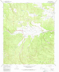
1965 Map of Luna
USGS Topo · Published 1987About this map
The Luna Valley serves as a high-altitude agricultural corridor in the mid-1960s, anchored by the settlement of Luna and its associated Ranger Station. Located within the Apache National Forest, the landscape is defined by the headwaters of the San Francisco River and a network of named springs and stock tanks like Foxy Grandpa Tank and Adair Spring. The presence of Indian Ruins near Centerfire Creek points to a long history of human habitation in these uplands, while the Sawmill and numerous named places such as the Old Campbell Place and Rayle Place reflect the 20th-century ranching and timber economy. Transport patterns of the era are evident in the transition from established routes like the Blue Road to more specialized ways including the Mail Trail and various Pack Trail segments through the San Francisco Mountains.
Find a feature on this map
41 named features on this map. Tap any name to fly to it.
Don’t see what you’re looking for? This feature index may not catch every label — zoom into the map to look around manually.
Map Details
Editions of this 1965 Luna Map
2 editions found
Other maps of this area

1915 · Reserve
USGS Topo · 1:125,000

1918 · Reserve
USGS Topo · 1:125,000

1922 · Nutrioso
USGS Topo · 1:125,000

1954 · Clifton
USGS Topo · 1:250,000

1957 · Clifton
USGS Topo · 1:250,000

1958 · Clifton
USGS Topo · 1:250,000

1958 · Alpine
USGS Topo · 1:62,500

1961 · Blue
USGS Topo · 1:62,500

1962 · Clifton
USGS Topo · 1:250,000
1965 · Reserve
USGS Topo · 1:24,000