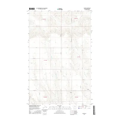
2017 Map of Lustre
USGS Topo · Published 2017About this map
Lustre stands as the primary settlement in this corner of Valley County, where the high plains are carved by a network of drainage systems. The landscape is defined by the branching paths of the W Fork Wolf Cr and the Middle Fork Wolf Cr, which cut through the terrain alongside Tree Coulee. This 2017 survey reveals a rural infrastructure built on a grid of local routes, including the Sauber-Peerless Rd and Academy Rd, which connect isolated farmsteads and ranching operations. The presence of M B Church Rd suggests the enduring importance of community focal points in this sparsely populated region. These roads follow the section lines of the Public Land Survey System, illustrating how 19th-century land divisions continue to dictate the modern transport patterns and property boundaries across the Montana landscape.
Find a feature on this map
21 named features on this map. Tap any name to fly to it.
Don’t see what you’re looking for? This feature index may not catch every label — zoom into the map to look around manually.
Map Details
Editions of this 2017 Lustre Map
This is the sole edition of this map. No revisions or reprints were ever made.
Other maps of this area

1910 · Todd Lakes
USGS Topo · 1:62,500

1915 · Todd Lakes
USGS Topo · 1:62,500

1915 · Spring Creek
USGS Topo · 1:62,500

1954 · Wolf Point
USGS Topo · 1:250,000

1954 · Glasgow
USGS Topo · 1:250,000

1957 · Glasgow
USGS Topo · 1:250,000

1958 · Wolf Point
USGS Topo · 1:250,000

1958 · Glasgow
USGS Topo · 1:250,000

1973 · Haugens Hill
USGS Topo · 1:24,000
1973 · Blink Springs
USGS Topo · 1:24,000