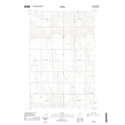
2020 Map of Lustre
USGS Topo · Published 2020About this map
Lustre serves as the primary focal point of this Valley County landscape, situated where the high plains meet the intricate drainage systems of the Missouri River watershed. The geography is defined by the carved paths of Middle Fork Wolf Cr and W Fork Wolf Cr, which illustrate the erosion patterns typical of this portion of the Frazer District. This 2020 survey highlights a remote but active rural network, where the Saubak Airport provides vital aerial access and roads like M B Church Rd and Lustre Rd connect isolated homesteads and agricultural tracts. A notable hydrological feature, the 31N35E16CBDB01 Spring, indicates the importance of groundwater sources in this semi-arid environment, while terrain features like Tree Coulee break the transition between upland plateaus and creek bottoms.
Find a feature on this map
23 named features on this map. Tap any name to fly to it.
Don’t see what you’re looking for? This feature index may not catch every label — zoom into the map to look around manually.
Map Details
Editions of this 2020 Lustre Map
This is the sole edition of this map. No revisions or reprints were ever made.
Other maps of this area

1910 · Todd Lakes
USGS Topo · 1:62,500

1915 · Todd Lakes
USGS Topo · 1:62,500

1915 · Spring Creek
USGS Topo · 1:62,500

1954 · Wolf Point
USGS Topo · 1:250,000

1954 · Glasgow
USGS Topo · 1:250,000

1957 · Glasgow
USGS Topo · 1:250,000

1958 · Wolf Point
USGS Topo · 1:250,000

1958 · Glasgow
USGS Topo · 1:250,000

1973 · Haugens Hill
USGS Topo · 1:24,000
1973 · Blink Springs
USGS Topo · 1:24,000