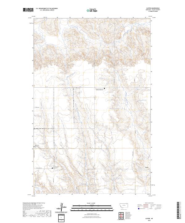
2024 Map of Lustre
USGS Topo · Published 2024About this map
Lustre and its surrounding prairie in Valley County are defined by a deep-rooted agricultural and religious heritage, centered on three distinct congregational sites. This landscape, surveyed in 2024, shows the concentration of community life around the Bethel Lustre Mennonite Cem, the Lustre Mennonite Brethren Cem, and the Evangelical Mennonite Brethren Church Cem. These features reflect the specific settlement patterns of the region's Mennonite families. The terrain is carved by the West Fork Wolf Creek and Middle Fork Wolf Creek, which create natural drainage patterns across the High Plains. A network of straight-line section roads, such as Academy Rd and Schmitt Rd, connects the scattered farmsteads and religious centers, illustrating the intersection of the Public Land Survey System with local social geography.
Find a feature on this map
28 named features on this map. Tap any name to fly to it.
Don’t see what you’re looking for? This feature index may not catch every label — zoom into the map to look around manually.
Map Details
Editions of this 2024 Lustre Map
This is the sole edition of this map. No revisions or reprints were ever made.
Other maps of this area

1910 · Todd Lakes
USGS Topo · 1:62,500

1915 · Todd Lakes
USGS Topo · 1:62,500

1915 · Spring Creek
USGS Topo · 1:62,500

1954 · Wolf Point
USGS Topo · 1:250,000

1954 · Glasgow
USGS Topo · 1:250,000

1957 · Glasgow
USGS Topo · 1:250,000

1958 · Wolf Point
USGS Topo · 1:250,000

1958 · Glasgow
USGS Topo · 1:250,000

1973 · Haugens Hill
USGS Topo · 1:24,000
1973 · Blink Springs
USGS Topo · 1:24,000