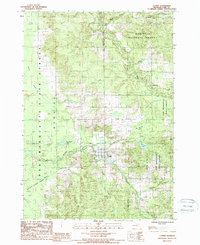
1987 Map of Luther
USGS Topo · Published 1988About this map
Luther serves as the primary hub of this Lake County landscape, situated at a bend in the Little Manistee River. During the late 1980s, this area remained characterized by dense forest cover and expansive wetlands, including the Baldwin-Luther Swamp and Baylor Swamp. The map documents a territory defined by conservation and recreation, split between the Manistee National Forest and the Pere Marquette State Forest.
Find a feature on this map
26 named features on this map. Tap any name to fly to it.
Don’t see what you’re looking for? This feature index may not catch every label — zoom into the map to look around manually.
Map Details
Editions of this 1987 Luther Map
This is the sole edition of this map. No revisions or reprints were ever made.
Other maps of this area

1931 · Chase NE
USGS Topo · 1:31,680

1931 · Baldwin NE
USGS Topo · 1:31,680

1932 · Chase NW
USGS Topo · 1:31,680

1933 · Peacock SE
USGS Topo · 1:31,680

1933 · Luther SE
USGS Topo · 1:31,680

1933 · Peacock NE
USGS Topo · 1:31,680

1933 · Luther SW
USGS Topo · 1:31,680

1933 · Luther NW
USGS Topo · 1:31,680

1954 · Traverse City
USGS Topo · 1:250,000

1954 · Midland
USGS Topo · 1:250,000