
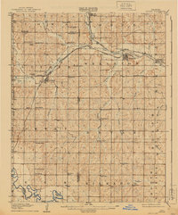
1909 Map of Luther
USGS Topo · Published 1909About this map
Luther and Wellston serve as the primary hubs of this central Oklahoma landscape just prior to statehood, where the convergence of the St. Louis and San Francisco RR and the Fort Smith and Western RR drove early development. The terrain is deeply carved by the Deep Fork of the Oklahoma and Canadian River, with numerous small tributaries like Captain Creek and Wildhorse Creek dictating the placement of early homesteads and community structures. The map reveals a dense network of rural infrastructure, including nearly twenty schools such as Sunnyside School and Arbuckle School, alongside landmarks like the German Church and Valley View Cemetery. In the southern reach, the North Fork Canadian River winds toward Horseshoe Lake, crossed at the Alexander Bridge, illustrating the vital river-and-rail economy of the era.
Find a feature on this map
54 named features on this map. Tap any name to fly to it.
Don’t see what you’re looking for? This feature index may not catch every label — zoom into the map to look around manually.
Map Details
Editions of this 1909 Luther Map
2 editions found
Other maps of this area

1892 · Moore
USGS Topo · 1:62,500

1892 · Guthrie
USGS Topo · 1:62,500

1892 · Edmond
USGS Topo · 1:62,500

1896 · Seminole and Prague
USGS Topo · 1:125,000

1898 · Purcell
USGS Topo · 1:125,000

1905 · Chandler
USGS Topo · 1:62,500

1907 · Chandler
USGS Topo · 1:62,500

1908 · Agra
USGS Topo · 1:62,500

1909 · Shawnee
USGS Topo · 1:62,500

1909 · Perkins
USGS Topo · 1:62,500