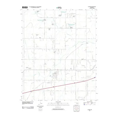
2010 Map of Luther
USGS Topo · Published 2010About this map
Luther serves as the primary hub of activity in this part of Oklahoma, situated along the Deep Fork river where the land is carved by local tributaries like Coon Creek and Wildhorse Creek. The 2010 landscape is heavily influenced by energy extraction, with the Luther Gas and Oil Field and the West Luther Oil and Gas Field surrounding the town. Water management is a defining characteristic of the northern terrain, where numerous small reservoirs including Bear Fall Coon Creek Site 21 Reservoir and Bear Fall Coon Creek Site 27 Reservoir dot the countryside. For those researching local heritage, several burial grounds are preserved across the area, such as Tillman Cemetery, Luther Cemetery, and Saint Luke Cemetery. Rural aviation is represented by private facilities like Bost Ranch Airport and Stamper Ranch Airport, while the Indian Meridian provides a foundational surveying line for the township's grid.
Find a feature on this map
62 named features on this map. Tap any name to fly to it.
Don’t see what you’re looking for? This feature index may not catch every label — zoom into the map to look around manually.
Map Details
Editions of this 2010 Luther Map
This is the sole edition of this map. No revisions or reprints were ever made.
Other maps of this area

1892 · Guthrie
USGS Topo · 1:62,500

1892 · Edmond
USGS Topo · 1:62,500

1909 · Luther
USGS Topo · 1:62,500

1909 · Perkins
USGS Topo · 1:62,500

1935 · Edmond
USGS Topo · 1:48,000

1940 · Edmond
USGS Topo · 1:62,500

1954 · Oklahoma City
USGS Topo · 1:250,000
1955 · Jones
USGS Topo · 1:24,000

1956 · Horseshoe Lake
USGS Topo · 1:24,000

1957 · Oklahoma City
USGS Topo · 1:250,000