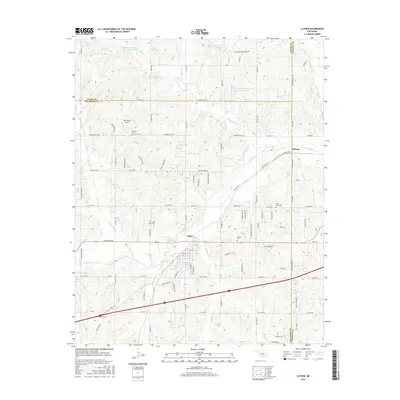
2016 Map of Luther
USGS Topo · Published 2016About this map
Luther serves as the central hub of this northeastern Oklahoma County landscape, situated where the Deep Fork river winds through a network of creeks and flood-control reservoirs. The map documents a rural transition zone where the traditional grid of section-line roads, such as Co Line Rd and Waterloo Rd, meets the undulating terrain of the Deep Fork basin. Several community landmarks provide anchor points for local history, including Saint Luke Cem and Tillman Cem, alongside the small settlement of Hibsaw to the northeast.
Find a feature on this map
46 named features on this map. Tap any name to fly to it.
Don’t see what you’re looking for? This feature index may not catch every label — zoom into the map to look around manually.
Map Details
Editions of this 2016 Luther Map
This is the sole edition of this map. No revisions or reprints were ever made.
Other maps of this area

1892 · Guthrie
USGS Topo · 1:62,500

1892 · Edmond
USGS Topo · 1:62,500

1909 · Luther
USGS Topo · 1:62,500

1909 · Perkins
USGS Topo · 1:62,500

1935 · Edmond
USGS Topo · 1:48,000

1940 · Edmond
USGS Topo · 1:62,500

1954 · Oklahoma City
USGS Topo · 1:250,000
1955 · Jones
USGS Topo · 1:24,000

1956 · Horseshoe Lake
USGS Topo · 1:24,000

1957 · Oklahoma City
USGS Topo · 1:250,000