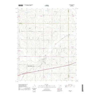
2018 Map of Luther
USGS Topo · Published 2018About this map
Luther serves as the focal point of this Oklahoma landscape, situated at the intersection of a complex drainage network that includes Deep Fork and Wildhorse Cr. The settlement patterns here are deeply tied to the rural geography where Logan, Lincoln, and Oklahoma Counties meet. For genealogists, the map is particularly useful for its identification of several burial sites, including Luther Cem, Saint Luke Cem, Reunion Cem, and Tillman Cem, which are scattered throughout the sections. The land is marked by numerous water management features such as the Bear Fall Coon Cr Site 26 Reservoir and its sister sites, reflecting the agricultural and conservation infrastructure of the region. Local transport is defined by long-standing routes like N Indian Meridian and the Diagonal Dr, which connect smaller centers like Hibsaw to the broader corridor leading toward Oklahoma City.
Find a feature on this map
82 named features on this map. Tap any name to fly to it.
Don’t see what you’re looking for? This feature index may not catch every label — zoom into the map to look around manually.
Map Details
Editions of this 2018 Luther Map
This is the sole edition of this map. No revisions or reprints were ever made.
Other maps of this area

1892 · Guthrie
USGS Topo · 1:62,500

1892 · Edmond
USGS Topo · 1:62,500

1909 · Luther
USGS Topo · 1:62,500

1909 · Perkins
USGS Topo · 1:62,500

1935 · Edmond
USGS Topo · 1:48,000

1940 · Edmond
USGS Topo · 1:62,500

1954 · Oklahoma City
USGS Topo · 1:250,000
1955 · Jones
USGS Topo · 1:24,000

1956 · Horseshoe Lake
USGS Topo · 1:24,000

1957 · Oklahoma City
USGS Topo · 1:250,000