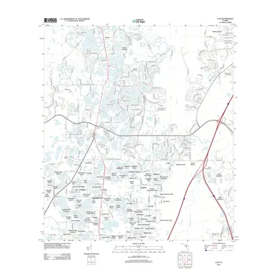
2012 Map of Lutz
USGS Topo · Published 2012About this map
Lutz and its surrounding lake-dotted landscape are meticulously detailed in this early 21st-century record of northern Hillsborough County. The region is characterized by an extensive network of named water bodies, including Big Lake Vienna, Saxon Lake, and Myrtle Lake, which have long defined the area's residential development and recreational character. Small settlements and specialized developments like Drexel, Dupree Gardens, and Wesley Chapel appear alongside newer residential pockets such as Lakes of Wellington and Eagle Crest.
Find a feature on this map
326 named features on this map. Tap any name to fly to it.
Don’t see what you’re looking for? This feature index may not catch every label — zoom into the map to look around manually.
Map Details
Editions of this 2012 Lutz Map
This is the sole edition of this map. No revisions or reprints were ever made.
Other maps of this area

1943 · Odessa
USGS Topo · 1:24,000

1943 · Thonotosassa
USGS Topo · 1:24,000

1943 · Lutz
USGS Topo · 1:24,000

1944 · Sulphur Springs
USGS Topo · 1:31,680

1944 · Wesley Chapel
USGS Topo · 1:31,680

1944 · Lutz
USGS Topo · 1:31,680

1944 · Odessa
USGS Topo · 1:31,680

1944 · Thonotosassa
USGS Topo · 1:31,680

1945 · Sulphur Springs
USGS Topo · 1:31,680
1947 · Citrus Park
USGS Topo · 1:24,000