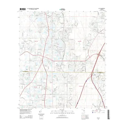
2015 Map of Lutz
USGS Topo · Published 2015About this map
The Pasco and Hillsborough County line divides this landscape of dense residential subdivisions and citrus-belt lakes. The unincorporated community of Lutz serves as a central hub, flanked by the smaller settlements of Bruing and Drexel. Transport and aviation are prominent features of the area's development, with small landing strips like Geraci Airpark and Tampa North Aero Park servicing local traffic. The natural geography is defined by a complex network of water bodies, including Lake Hobbs, Big Lake Vienna, and Hog Island Lake, many of which are surrounded by suburban sprawl. In the east, the terrain transitions toward the drainage of Cypress Creek and the wooded Buck Hammock, illustrating the suburban transformation of Florida's interior lake country into the modern Tampa metropolitan periphery. Notable road corridors like Ehren Cutoff and Parkway Blvd link these disparate lakeside developments.
Find a feature on this map
277 named features on this map. Tap any name to fly to it.
Don’t see what you’re looking for? This feature index may not catch every label — zoom into the map to look around manually.
Map Details
Editions of this 2015 Lutz Map
This is the sole edition of this map. No revisions or reprints were ever made.
Other maps of this area

1943 · Odessa
USGS Topo · 1:24,000

1943 · Thonotosassa
USGS Topo · 1:24,000

1943 · Lutz
USGS Topo · 1:24,000

1944 · Sulphur Springs
USGS Topo · 1:31,680

1944 · Wesley Chapel
USGS Topo · 1:31,680

1944 · Lutz
USGS Topo · 1:31,680

1944 · Odessa
USGS Topo · 1:31,680

1944 · Thonotosassa
USGS Topo · 1:31,680

1945 · Sulphur Springs
USGS Topo · 1:31,680
1947 · Citrus Park
USGS Topo · 1:24,000