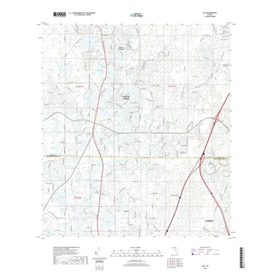
2018 Map of Lutz
USGS Topo · Published 2018About this map
Lutz and Land O' Lakes anchor this landscape along the Pasco Co Hillsborough Co line, illustrating the intense suburban development characteristic of the northern Tampa corridor. The area is defined by a high density of named water bodies, including Lake Thomas, Bell Lake, and Big Lake Vienna, which dictate the winding patterns of local roads like Land O' Lakes Blvd and Lake Thomas Rd. This 2018 survey shows a transition from residential clusters near the historic settlement of Drexel and the botanical legacy of Dupree Gardens to modern transportation infrastructure. Aviation influence is visible through the presence of Geraci Airpark and Tampa North Aero Park, while the eastern portion of the map remains slightly more open near the swampy terrain of Buck Hammock and the northern reaches of Tampa.
Find a feature on this map
257 named features on this map. Tap any name to fly to it.
Don’t see what you’re looking for? This feature index may not catch every label — zoom into the map to look around manually.
Map Details
Editions of this 2018 Lutz Map
This is the sole edition of this map. No revisions or reprints were ever made.
Other maps of this area

1943 · Odessa
USGS Topo · 1:24,000

1943 · Thonotosassa
USGS Topo · 1:24,000

1943 · Lutz
USGS Topo · 1:24,000

1944 · Sulphur Springs
USGS Topo · 1:31,680

1944 · Wesley Chapel
USGS Topo · 1:31,680

1944 · Lutz
USGS Topo · 1:31,680

1944 · Odessa
USGS Topo · 1:31,680

1944 · Thonotosassa
USGS Topo · 1:31,680

1945 · Sulphur Springs
USGS Topo · 1:31,680
1947 · Citrus Park
USGS Topo · 1:24,000