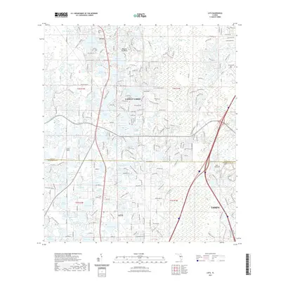
2021 Map of Lutz
USGS Topo · Published 2021About this map
Lutz and Land O' Lakes anchor this modern survey of the lake-studded landscape straddling the line between Pasco and Hillsborough counties. The area is defined by its complex hydrology, where numerous named water bodies like Big Lake Vienna, Myrtle Lake, and Dupree Lake are interspersed with dense residential developments and the sprawling wetlands of Big Cypress Swamp. The map documents the continued suburban expansion toward the northern reaches of Tampa, following the corridors of major thoroughfares like Sunset Lane and Van Dyke Road. Cultural landmarks such as the Geraci Airpark and the historic location of Dupree Gardens provide points of interest for local historians, while the natural character of the terrain is preserved in features like Buck Hammock and Cabbage Swamp. This detailed view of the central Florida peninsula captures the modern intersection of rapid residential growth and the fragile wetland ecosystems of the Cypress Creek watershed.
Find a feature on this map
85 named features on this map. Tap any name to fly to it.
Don’t see what you’re looking for? This feature index may not catch every label — zoom into the map to look around manually.
Map Details
Editions of this 2021 Lutz Map
This is the sole edition of this map. No revisions or reprints were ever made.
Other maps of this area

1943 · Odessa
USGS Topo · 1:24,000

1943 · Thonotosassa
USGS Topo · 1:24,000

1943 · Lutz
USGS Topo · 1:24,000

1944 · Sulphur Springs
USGS Topo · 1:31,680

1944 · Wesley Chapel
USGS Topo · 1:31,680

1944 · Lutz
USGS Topo · 1:31,680

1944 · Odessa
USGS Topo · 1:31,680

1944 · Thonotosassa
USGS Topo · 1:31,680

1945 · Sulphur Springs
USGS Topo · 1:31,680
1947 · Citrus Park
USGS Topo · 1:24,000