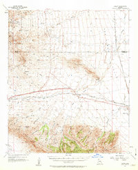
1957 Map of Luzena
USGS Topo · Published 1963About this map
Luzena serves as a small rail siding in the mid-century landscape of the San Simon Valley, situated at the intersection of the Southern Pacific railroad and the desert foothills. The map reveals a land defined by water management and ranching operations, with family-named outposts such as Ten Ranch, Monk Ranch, and Bartlett Ranch scattered across the basin and its draws. To the south, the dramatic rise of the Dos Cabezas Mountains and Maverick Mountain dominates the terrain, where complex drainages like Cowboy Canyon and Buckeye Canyon cut through the high ground.
Find a feature on this map
51 named features on this map. Tap any name to fly to it.
Don’t see what you’re looking for? This feature index may not catch every label — zoom into the map to look around manually.
Map Details
Editions of this 1957 Luzena Map
2 editions found

Other maps of this area

1917 · San Simon
USGS Topo · 1:125,000

1922 · Willcox
USGS Topo · 1:125,000

1926 · Cochise Head
USGS Topo · 1:62,500

1928 · Bowie
USGS Topo · 1:62,500

1942 · Mt. Graham
USGS Topo · 1:62,500

1943 · Dos Cabezas
USGS Topo · 1:62,500

1943 · Willcox
USGS Topo · 1:62,500

1943 · Cochise
USGS Topo · 1:62,500

1944 · Fisher Hills
USGS Topo · 1:62,500

1945 · Mt. Graham
USGS Topo · 1:62,500