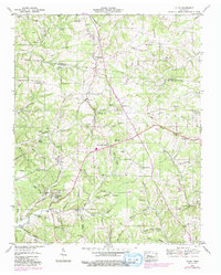
1953 Map of Lyles
USGS Topo · Published 1992About this map
Lyles and Wrigley anchor the central valley of this mid-century survey, which documents a landscape defined by the Tenn Valley Divide crossing from east to west. The area's complex topography is etched with dozens of named hollows, including Potts Hollow and Ward Hollow, serving as a record of local family landholdings and rural settlement patterns. In the northern reaches, the community of Bon Aqua sits near Bon Aqua Spring, while infrastructure like the Bon Aqua Lookout Tower and an Airway Beacon to the east highlight the era's navigational and fire-prevention networks.
Find a feature on this map
94 named features on this map. Tap any name to fly to it.
Don’t see what you’re looking for? This feature index may not catch every label — zoom into the map to look around manually.
Map Details
Editions of this 1953 Lyles Map
3 editions found
Other maps of this area

1901 · Colombia
USGS Topo · 1:125,000

1930 · White Bluff
USGS Topo · 1:62,500

1933 · White Bluff
USGS Topo · 1:62,500

1936 · Primm
USGS Topo · 1:24,000

1936 · Nunnelly
USGS Topo · 1:24,000

1936 · Littlelot
USGS Topo · 1:24,000

1936 · Texas Hollow
USGS Topo · 1:24,000

1936 · Burns
USGS Topo · 1:24,000

1936 · Craigfield
USGS Topo · 1:24,000

1936 · Lyles
USGS Topo · 1:24,000