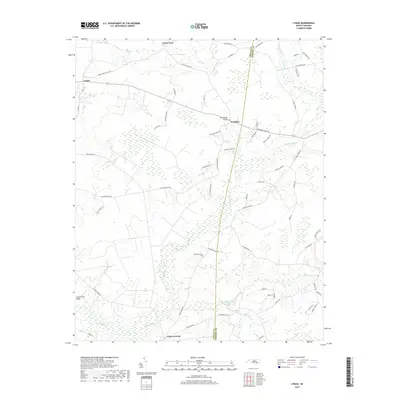
2019 Map of Lyman
USGS Topo · Published 2019About this map
Lyman and the rural communities of Cedar Fork and Fountain define the landscape of this Duplin County region, where the county line with Onslow County runs through a network of creeks and swamps. The terrain is a complex hydrologic system marked by Back Swamp, Ninemile Cr, and Tenmile Cr, illustrating the low-lying coastal plain environment. Land use appears concentrated along established routes like Fountaintown Rd and Cypress Creek Rd, with Bethlehem Church serving as a central community landmark. The presence of Long Straw Ridge provides a slight topographical contrast to the surrounding drainage basins of Cypress Creek and the Lee Baysden Pond area. For genealogists, the map preserves the names of numerous local families through roads such as Eneas Lanier Rd, Arthur Sloan Rd, and Kenan Graham Ln, which trace the historical ownership and settlement patterns of this agrarian section of North Carolina.
Find a feature on this map
59 named features on this map. Tap any name to fly to it.
Don’t see what you’re looking for? This feature index may not catch every label — zoom into the map to look around manually.
Map Details
Editions of this 2019 Lyman Map
This is the sole edition of this map. No revisions or reprints were ever made.
Other maps of this area

1942 · Burgaw
USGS Topo · 1:62,500

1943 · Kenansville
USGS Topo · 1:62,500

1948 · Kenansville
USGS Topo · 1:62,500

1948 · Maple Hill
USGS Topo · 1:62,500

1948 · Richlands
USGS Topo · 1:62,500

1953 · Beaufort
USGS Topo · 1:250,000

1954 · Beaufort
USGS Topo · 1:250,000

1965 · Richlands
USGS Topo · 1:62,500

1972 · Beaufort
USGS Topo · 1:250,000
1980 · Richlands
USGS Topo · 1:62,500