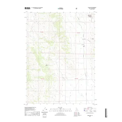
2020 Map of Lyman Pass
USGS Topo · Published 2020About this map
Sawtooth National Forest lands dominate the northeastern corner of this area, marking a transition into the high terrain of the Albion Mountains. The topography is defined by the significant divide between Middle Mountain and the surrounding basins, with the prominent Lyman Pass serving as a natural corridor into Junction Valley. A network of remote water sources and drainages, including Slide Spring, Birch Creek, and Cottonwood Creek, suggests a landscape historically utilized for livestock grazing and movement through the high desert canyons. The presence of Emery Canyon Rd and Birch Creek Rd indicates the primary routes used to navigate these valleys, following the natural contours of Emery Canyon as it cuts through the mountains. This 2020 record documents the hydrography and elevation of a sparsely populated but geographically complex section of Cassia County.
Find a feature on this map
24 named features on this map. Tap any name to fly to it.
Don’t see what you’re looking for? This feature index may not catch every label — zoom into the map to look around manually.
Map Details
Editions of this 2020 Lyman Pass Map
This is the sole edition of this map. No revisions or reprints were ever made.
Other maps of this area

1954 · Pocatello
USGS Topo · 1:250,000

1954 · Brigham City
USGS Topo · 1:250,000

1958 · Pocatello
USGS Topo · 1:250,000

1958 · Brigham City
USGS Topo · 1:250,000

1959 · Cotton Thomas Basin
USGS Topo · 1:62,500

1959 · Yost
USGS Topo · 1:62,500

1962 · Brigham City
USGS Topo · 1:250,000

1968 · Almo
USGS Topo · 1:24,000

1968 · Cache Peak
USGS Topo · 1:24,000

1968 · Basin
USGS Topo · 1:24,000