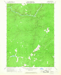
1966 Map of Lynch
USGS Topo · Published 1968About this map
Tionesta Creek flows through the heart of the Allegheny National Forest in this mid-1960s study of the Forest County interior. The landscape is heavily defined by extraction, with numerous Oil Wells and a dedicated Oil Field scattered across the wooded drainages of Bush Creek and Bluejay Creek. Small, isolated settlements like Lynch, Pigeon, and Byromtown are linked by an Old Railroad Grade and the Baltimore and Ohio Railroad Grade, illustrating a transition from active rail transit to a more industrial and recreational land use. Several evocatively named locations, such as Seldom Seen Corners and Deadman Corners, hint at the remote character of the plateau. Infrastructure of the era is represented by a Compressor Sta and a Gaging Sta, while the Blue Jay Spring Recreation Area and Beaver Meadows Lake highlight the region's burgeoning importance for outdoor leisure.
Find a feature on this map
48 named features on this map. Tap any name to fly to it.
Don’t see what you’re looking for? This feature index may not catch every label — zoom into the map to look around manually.
Map Details
Editions of this 1966 Lynch Map
Other maps of this area

1918 · Loleta
USGS Topo · 1:62,500

1934 · Kane
USGS Topo · 1:48,000

1935 · Sheffield
USGS Topo · 1:48,000

1936 · Marienville
USGS Topo · 1:48,000

1939 · Kane
USGS Topo · 1:62,500

1940 · Hallton
USGS Topo · 1:48,000

1941 · Sheffield
USGS Topo · 1:62,500

1941 · Marienville
USGS Topo · 1:62,500

1943 · Hallton
USGS Topo · 1:62,500

1947 · Cherry Grove
USGS Topo · 1:24,000
Featured Places
- Sheffield Township, PA
- Howe Township, PA
- Jenks Township, PA
- Lynch, Howe Township
- Iron City, Howe Township