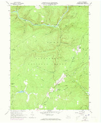
1966 Map of Lynch
USGS Topo · Published 1973About this map
Tionesta Creek winds through this section of the Allegheny National Forest, where industrial activity and resource extraction define the landscape. Numerous Oil Wells and an extensive Oil Field are scattered across the terrain, concentrated near settlements like Iron City and Lynch. The map reveals the infrastructure of the era, including a Compressor Sta Radio Tower and a Lookout Tower near the southern boundary.
Find a feature on this map
46 named features on this map. Tap any name to fly to it.
Don’t see what you’re looking for? This feature index may not catch every label — zoom into the map to look around manually.
Map Details
Editions of this 1966 Lynch Map
Other maps of this area

1918 · Loleta
USGS Topo · 1:62,500

1934 · Kane
USGS Topo · 1:48,000

1935 · Sheffield
USGS Topo · 1:48,000

1936 · Marienville
USGS Topo · 1:48,000

1939 · Kane
USGS Topo · 1:62,500

1940 · Hallton
USGS Topo · 1:48,000

1941 · Sheffield
USGS Topo · 1:62,500

1941 · Marienville
USGS Topo · 1:62,500

1943 · Hallton
USGS Topo · 1:62,500

1947 · Cherry Grove
USGS Topo · 1:24,000
Featured Places
- Sheffield Township, PA
- Howe Township, PA
- Jenks Township, PA
- Lynch, Howe Township
- Iron City, Howe Township