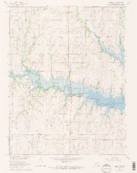
1965 Map of Lyndon NW
USGS Topo · Published 1966About this map
Pomona Reservoir dominates this mid-1960s landscape, having transformed the drainage of Dragoon Creek and Hundred and Ten Mile Creek. The reservoir's creation significantly altered the local geography, visible here with the establishment of Carbolyn State Park and a Roadside Park along the northern shore. A significant historical marker, the Old Indian Treaty Boundary, cuts diagonally across the township lines, serving as a reminder of earlier 19th-century land divisions.
Find a feature on this map
22 named features on this map. Tap any name to fly to it.
Don’t see what you’re looking for? This feature index may not catch every label — zoom into the map to look around manually.
Map Details
Editions of this 1965 Lyndon NW Map
2 editions found
Other maps of this area

1889 · Burlingame
USGS Topo · 1:125,000

1894 · Burlingame
USGS Topo · 1:125,000

1947 · Lawrence
USGS Topo · 1:250,000

1950 · Lawrence
USGS Topo · 1:250,000

1952 · Burlingame
USGS Topo · 1:24,000

1955 · Overbrook
USGS Topo · 1:24,000

1955 · Carbondale
USGS Topo · 1:24,000

1956 · Lawrence
USGS Topo · 1:250,000

1961 · Lawrence
USGS Topo · 1:250,000
1965 · Lyndon
USGS Topo · 1:24,000