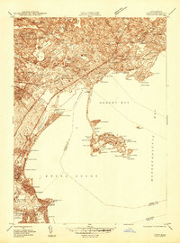
1944 Map of Lynn
USGS Topo · Published 1944About this map
The Lynn coastline and its surrounding North Shore communities are captured in this mid-century survey, showcasing a landscape defined by dense urban development and intricate coastal geography. Industrial and residential corridors are linked by the Boston and Maine RR and the Boston Revere Beach and Lynn RR, which parallel the shoreline from Beachmont toward the heart of the city. Notable social and civic infrastructure is visible, including the City Farm, Isolation Hospital, and the prominent Classical High Sch.
Find a feature on this map
153 named features on this map. Tap any name to fly to it.
Don’t see what you’re looking for? This feature index may not catch every label — zoom into the map to look around manually.
Map Details
Editions of this 1944 Lynn Map
This is the sole edition of this map. No revisions or reprints were ever made.
Other maps of this area

1886 · Lawrence
USGS Topo · 1:62,500

1888 · Lawrence
USGS Topo · 1:62,500

1888 · Salem
USGS Topo · 1:62,500

1892 · Boston Bay
USGS Topo · 1:62,500

1893 · Salem
USGS Topo · 1:62,500

1893 · Boston
USGS Topo · 1:62,500

1893 · Lawrence
USGS Topo · 1:62,500

1903 · Boston
USGS Topo · 1:62,500

1903 · Boston Bay
USGS Topo · 1:62,500

1917 · Salem
USGS Topo · 1:62,500