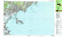
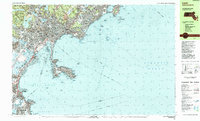
1985 Map of Lynn
USGS Topo · Published 1985About this map
Lynn Woods dominates the northern landscape of this coastal survey, preserving a dense network of hills and ponds including Walden Pond and Mt Gilead. The urban centers of Lynn and Swampscott transition into the jagged shoreline of the North Shore, where the B & M railroad cuts through established neighborhoods. This 1985 edition reflects the high-water mark of mid-century coastal development, showing the dense residential patterns from East Saugus to the distinct peninsula of Nahant.
Find a feature on this map
140 named features on this map. Tap any name to fly to it.
Don’t see what you’re looking for? This feature index may not catch every label — zoom into the map to look around manually.
Map Details
Editions of this 1985 Lynn Map
2 editions found
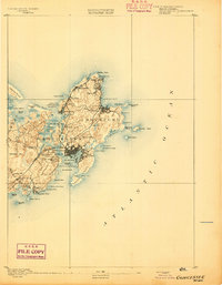
Other maps of this area

1886 · Gloucester
USGS Topo · 1:62,500

1886 · Lawrence
USGS Topo · 1:62,500

1888 · Gloucester
USGS Topo · 1:62,500

1888 · Lawrence
USGS Topo · 1:62,500

1888 · Salem
USGS Topo · 1:62,500

1892 · Boston Bay
USGS Topo · 1:62,500

1893 · Salem
USGS Topo · 1:62,500

1893 · Boston
USGS Topo · 1:62,500

1893 · Lawrence
USGS Topo · 1:62,500
1893 · Gloucester
USGS Topo · 1:62,500