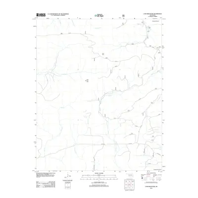
2012 Map of Lynn Mountain
USGS Topo · Published 2012About this map
The high peaks of Lynn Mtn and Blue Bouncer Mtn dominate this section of the Ouachita Mountains in LeFlore County. The landscape is defined by a dense network of watercourses carving through the elevations, including the substantial drainage of Beech Cr and the winding paths of Cucumber Cr and Hurricane Cr. Towards the northern boundary, Phillips Mountain rises near the headwaters of Pigeon Cr and Horse Bone Cr. This 2012 survey illustrates a remote highland area where human infrastructure is largely limited to forest service routes and rural county roads like N Beachton Rd and Loop Rd. The map serves as a detailed record of the natural topography and the myriad named branches and creeks, such as Golden Br and Rattlesnake Cr, that define the watershed of this rugged Oklahoma interior.
Find a feature on this map
21 named features on this map. Tap any name to fly to it.
Don’t see what you’re looking for? This feature index may not catch every label — zoom into the map to look around manually.
Map Details
Editions of this 2012 Lynn Mountain Map
This is the sole edition of this map. No revisions or reprints were ever made.
Other maps of this area

1890 · Poteau Mountain
USGS Topo · 1:125,000

1899 · Poteau Mountain
USGS Topo · 1:125,000

1900 · Winding Stair
USGS Topo · 1:125,000

1902 · Lukfata
USGS Topo · 1:125,000

1909 · Winding Stair
USGS Topo · 1:125,000

1913 · De Queen
USGS Topo · 1:125,000

1950 · Mcalester
USGS Topo · 1:250,000

1958 · Potter
USGS Topo · 1:62,500

1958 · Zafra
USGS Topo · 1:24,000
1958 · Mountain Fork
USGS Topo · 1:24,000