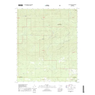
2018 Map of Lynn Mountain
USGS Topo · Published 2018About this map
The Kiamichi Mountains dominate this section of the Ouachita National Forest, where a network of forest roads and trails reveals the complex topography of LeFlore and McCurtain counties. Higher elevations are defined by prominent peaks including Lynn Mtn, Blue Bouncer Mtn, and Walnut Mtn, which serve as the headwaters for numerous drainage systems. These slopes are etched by deep creek beds, notably Cucumber Cr and Beech Cr, illustrating the watershed's role in the regional hydrology.
Find a feature on this map
35 named features on this map. Tap any name to fly to it.
Don’t see what you’re looking for? This feature index may not catch every label — zoom into the map to look around manually.
Map Details
Editions of this 2018 Lynn Mountain Map
This is the sole edition of this map. No revisions or reprints were ever made.
Other maps of this area

1890 · Poteau Mountain
USGS Topo · 1:125,000

1899 · Poteau Mountain
USGS Topo · 1:125,000

1900 · Winding Stair
USGS Topo · 1:125,000

1902 · Lukfata
USGS Topo · 1:125,000

1909 · Winding Stair
USGS Topo · 1:125,000

1913 · De Queen
USGS Topo · 1:125,000

1950 · Mcalester
USGS Topo · 1:250,000

1958 · Potter
USGS Topo · 1:62,500

1958 · Zafra
USGS Topo · 1:24,000
1958 · Mountain Fork
USGS Topo · 1:24,000