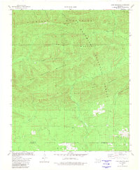
1981 Map of Lynn Mountain
USGS Topo · Published 1981About this map
The Kiamichi Mountains dominate this 1981 survey of the Ouachita National Forest along the border of Le Flore and McCurtain Counties. This area is characterized by high, wooded ridges and a complex network of named waterways, including the headwaters of Beech Creek and Horse Bone Creek. The topography is defined by prominent peaks such as Lynn Mountain, Blue Bouncer Mountain, and Walnut Mountain. A narrow corridor of human activity is visible in the southeastern portion of the map, centered around the Zafra Ch. This small landmark, alongside a few scattered structures and unimproved roads, marks the extent of settlement in this heavily forested landscape. To the north, Pigeon Creek and Cucumber Creek cut through deep valleys, while the Base Line serves as a primary surveying marker across the southern half of the quadrangle.
Find a feature on this map
22 named features on this map. Tap any name to fly to it.
Don’t see what you’re looking for? This feature index may not catch every label — zoom into the map to look around manually.
Map Details
Editions of this 1981 Lynn Mountain Map
This is the sole edition of this map. No revisions or reprints were ever made.
Other maps of this area

1890 · Poteau Mountain
USGS Topo · 1:125,000

1899 · Poteau Mountain
USGS Topo · 1:125,000

1900 · Winding Stair
USGS Topo · 1:125,000

1902 · Lukfata
USGS Topo · 1:125,000

1909 · Winding Stair
USGS Topo · 1:125,000

1913 · De Queen
USGS Topo · 1:125,000

1950 · Mcalester
USGS Topo · 1:250,000

1958 · Potter
USGS Topo · 1:62,500

1958 · Zafra
USGS Topo · 1:24,000
1958 · Mountain Fork
USGS Topo · 1:24,000