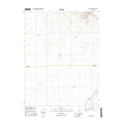
2017 Map of Lynndyl West
USGS Topo · Published 2017About this map
Lynndyl serves as the focal point for this section of the Sevier Desert, situated along the southern edge of the survey area near the border of Millard and Juab Counties. The settlement's layout is defined by the intersection of Main St and Railroad Ave, reflecting its identity as a transportation hub. A railroad line, labeled here as Lynndyl W 3, cuts diagonally across the landscape, while the local street grid is further delineated by routes like S 100 W. To the north, the terrain transitions into a more arid environment dominated by the Sand Mtn Hills and the solitary protrusion of The Knoll. The ephemeral Tanner Cr marks one of the few named water features in this high desert region, tracing a path through the northeastern corner.
Find a feature on this map
13 named features on this map. Tap any name to fly to it.
Don’t see what you’re looking for? This feature index may not catch every label — zoom into the map to look around manually.
Map Details
Editions of this 2017 Lynndyl West Map
This is the sole edition of this map. No revisions or reprints were ever made.
Other maps of this area

1885 · Sevier Desert
USGS Topo · 1:250,000

1951 · Oak City
USGS Topo · 1:62,500

1953 · Delta
USGS Topo · 1:250,000

1958 · Delta
USGS Topo · 1:250,000

1962 · Delta
USGS Topo · 1:250,000

1962 · Lynndyl
USGS Topo · 1:62,500

1962 · Delta
USGS Topo · 1:62,500

1971 · Rain Lake
USGS Topo · 1:24,000
1971 · Desert Mtn Reservoir
USGS Topo · 1:24,000

1979 · Lynndyl
USGS Topo · 1:100,000